This
arrived a few days ago, just in time for Christmas; my Worked All States
certificate! Mighty proud! Earned for working all 50 states of the USA,
including Alaska and Hawaii. Working them is one thing, getting them all
confirmed in LotW is another. In the spring of 2015 I worked Hawaii,
and with that already unofficially completed my WAS. Oregon was a tough
nut to crack though QSL-wise. But a couple of weeks ago a long-awaited LotW QSL came in for Oregon, and I finally had all 50 states
confirmed, eventually resulting in the certificate shown here!
All states
are confirmed in SSB and/or CW, except for North Dakota, South Dakota,
and Wyoming, which are confirmed only in digital modes JT65 or JT9.
In addition to my blog entry of November 12th, Mont Blanc SOTA F/AB-001, here's some more information from Gérald F6HBI. The photos below are taken with his kind permission from Gérald's Flickr pages. More photos can be found on the Flickr pages listed at the end of this blog entry.
Gérald wrote to me that indeed the F8UFT team for August 16th had planned to climb and activate Mont Blanc du Tacul SOTA F/AB-003 and Aguille du Midi F/AB-015 on returning, but the glacier of Mont Blanc du Tacul had dropped down and in its disastrous path killed three people, which made the F8UFT team decide it was better to cancel the climb and do a training session somewhere else.
For the SOTA chaser following the expedition from his "arm chair" and the comfort of his home, with the scenic picture postcards of the area in mind, it's easy to forget how hostile and dangerous the mountains can be. In the time the F8UFT team was there, in the area no less than 10 people have lost their lives in the mountains. Another OM that also wanted to climb and activate the Mont Blanc got stuck in a cable car at 3640 metres height and had to spend the night in there. The ordeal of OM F5OUX even got coverage on the TV news.
The breathtaking video of the F8UFT team descending the Aguille du Midi can now be found here, and definitely is a MUST-WATCH:
An expedition video and QSL cards are still in the making. I'll keep you posted.
Articles on the F8UFT Mont Blanc expedition also appeared in La Pioche (the news bulletin of the UFT - Union Française des Télégraphistes) issue nr. 121 4/2016, and Radio-REF (the news bulletin of the REF - Réseau des Émetteurs Français) issue nr. 903 November 2016.
Many thanks to Gérald, F6HBI for the information. Merci beaucoup, Gérald!
André, F6IGY with his VHF looking at the Mont Blanc summit.
The UFT flag and the two CW stations on the summit of the Mont Blanc. Frédéric, F8DQY on 40m in the back. Gérald, F6HBI on 30m in the front.
Gérald, F6HBI at the key at 4,810 m height on the summit of the Mont Blanc.
The F8UFT team arriving on the summit of Mont Buet. The Mont Blanc can be seen in the background at the right.
Here's a beautiful folded QSL card received recently for my 40m CW contact with the CY9C DXpedition on St. Paul Island, IOTA NA-094.
St. Paul Island lies about 25 kilometres off the northern tip of Nova Scotia, Canada on the border of the North Atlantic and the Gulf of St. Lawrence. St. Paul is a rugged island of approximately 5 kilometres long and 2 kilometres wide. The island is surrounded by rockface cliffs and is uninhabited. Due to fog and the often extreme and unpredictable weather conditions in the area, the rocky cliffs of the island in the past centuries have seen numerous catastrophic ship wrecks, and therefore the island sometimes is also nicknamed The Graveyard of the Gulf.
You can find a huge amount of information about this fascinating island on www.stpaulisland.net. On this site there's also a separate section with a "QSL Museum" with historical QSL cards of amateur radio stations having been active from St. Paul Island in the past and as recent as 2012, as well as a section with links and other information about various other CY9 DXpeditions.
The CY9C DXpedition was active from two operational sites: Atlantic Cove and Northeast Point. Actually, the Northeast Point is a separate small island of just a few acres in size and separated from the main island by a small strip of water.
According to Phil McBride, VA3QR, one of the operators of the DXpedition, my 40m CW contact was with operator K4ZLE at the Atlantic Cove site. During the DXpedition, VA3QR kept a very nice daily blog which can be found here. You can read about mysteriously disappearing chartered boat captains, logistical problems, nasty storms, blown down tents, fog systems, and the other daily events that made this DXpedition quite the challenge and adventure.
Beside a chartered boat, the CY9C team also had the luxury of having to their disposal a helicopter to transport equipment and team members to and from the island. The helicopter is owned by team member N2IENand can be seen on the QSL card. There's no way that a boat can get equipment to the Northeast Point, so all gear for this site had to be ferried by the chopper. Also, along with gear, generator fuel, and supplies, frequently USB sticks with the log of the operators at Atlantic Cove were flown from the Atlantic Cove site to the Northeast Point where VA3QR could then upload it to Clublog via a cellular internet connection with either the Newfoundland or Nova Scotia mainland, that's not clear to me. There was no cellular coverage at the Atlantic Cove site.
St. Paul Island is a separate DXCC entity. It's number 72 on the DXCC Most Wanted List of Clublog (no surprise, North Korea is number 1). Do not misunderstand me, I'm glad St. Paul is a DXCC entity, and I don't want to have it changed, but I'm really curious as to why it is. The island is part of Nova Scotia, Canada, and it's relatively close to the coast of Nova Scotia and Newfoundland, so from my point of view there's not really a clear political or geographical distinctiveness. Maybe one of my blog readers can shed some light on the underlying reasons for St. Paul being on the DXCC list. Again, do not misunderstand me, I'm not promoting here to have it removed from the list, because as far as I'm concerned, the more DXCC entities the better!
Addendum 25.07.2017 The complete story, written by the expedition members themselves, can now be found here.
Last edited: 19.11.2016 - Added various information and links to F6HBI's Flickr pages with spectacular photos of the expedition. 11.12.2016 - See also my blog entry of December 11th with additional information from F6HBI.
Somewhere in the autumn of 2015, announcements started to appear that a group of French hams of the Union Française des Télégraphistes (UFT) were planning a combined ham radio / mountaineering expedition to the top of the Mont Blanc. Located in the Alps on the border of eastern France and Italy, and rising to a height of almost 4,810 meters a.s.l., the Mont Blanc is Western Europe's highest mountain (in Europe only topped in height by a couple of mountains in the Caucasus). It's ranked 11th in the world in topographic prominence. The Summits on the Air (SOTA) reference for the Mont Blanc is F/AB-001.
I had just started actively chasing SOTA activators in CW, and I was really excited about the news. The expedition would take place in August of 2016. I would have almost a whole year to look forward to it and to get myself ready to put this special activation in the log.
By the summer of 2016 more information followed. The expedition team of 8 members had been assembled and consisted of Christian F8GHE, Gérald F6HBI, Frédéric F8DQY, André F6IGY, Mathieu F4EZO, Jean-Guy, Serge, and Théo. Another team member is mentioned, Jean F5BQT, and I believe he was the expedition's base camp VHF radioman down in the valley. Team member Gérald F6HBI is a well known and very active CW SOTA activator, and I had worked him many times before on various mountains throughout southeastern France. The team would use the callF8UFT, the callsign of the Union Française des Télégraphistes.
The F8UFT team would stay in the Chamonix-Mont-Blanc area for about a month, and as part of their training, preparation, and acclimatization for the climb of the Mont Blanc, several other mountains in the area would be ascended and activated on the ham bands.
The first contact I made with the team was on August 1st, 2016 on 30m CW. The operator was Gérald F6HBI, located on the summit of Le Brévent (SOTA F/AB-258) at 2525m height. The callsign used was F8UFT/P. On all the activations that followed later in August, the /P was omitted. The 30m signal was good and solid, and I had no problems making the contact.
My next contact was on August 6th. I worked operator Gérald F6HBI on 30m CW and operator Frédéric F8DQY on 40m CW on the summit of Mont Buet (F/AB-126) at 3096m height.
The activation date of the Mont Blanc was set to August 21, and while this date was getting closer and closer, in the meantime on August 12th I managed to work the team again on 40m CW (operator Frédéric F8DQY), this time on Le Prarion (SOTA F/AB-362) at 1969m height.
Expedition leader André F6IGY at the key on the summit of Mont Buet 06.08.2016 (source)
Frédéric F8DQY at the key at Mer de Glace 04.08.2016 (source)
On SOTAwatch, for August 16th also the activation of Mont Blanc du Tacul F/AB-003 (4248m) and Aguille du Midi F/AB-015 (3842m) was announced, but as far as I know these activations didn't take place. I don't know the reason for this, but maybe weather conditions or difficult, unsafe, or unsuitable operating conditions at the summit made the team decide not to spend time on any ham activities there.
The team did go up the Aguille du Midi, as the men could be seen in a spectacular YouTube video posted by Gérald F6HBI going down the knife-edge ridge of the Aguille du Midi Arête. Unfortunately, Gérald for reasons unknown recently removed the video from YouTube.
I was now really looking forward to the activation of the "Big One" on August 21st. The easy contacts with the team during their earlier activations had made me believe working them on the Mont Blanc was going to be a piece of cake. This however turned out to be far from the truth.
The plans of the F8UFT team were to start climbing for the top of the Mont Blanc in the early morning of August 21st from the Tête Rousse Hut at 3167m height. Excellent, I thought, August 21st being on a Sunday.
Then the news was brought out on SOTA Reflector that the team had changed their plans and would climb the Mont Blanc on August 24th. This date would allow them to sleep in the Goûter Hut at 3815m height, closer to the top of the Mont Blanc, allowing them to reach the top in less time and increasing the chance of succes. They would start climbing in darkness at 03:00 hours in the morning and expected to reach the top at 09:30-10:00 hours local time. This new date also meant that I had to take a day off from work. Much to my dismay the company didn't give permission, but luckily it turned out I had the late shift that day, and I would be able to spend time in the radio shack until about 3 in the afternoon!
So on the morning of August 24th I was awake early and was all set for working the Mont Blanc (SOTA F/AB-001). I kept an eye on the SOTAwatch cluster and followed Gérald F6HBI on APRS.fi. I was also switching between the announced frequencies of 7.013 and 10.122 MHz monitoring for a CQ from the F8UFT team. Frédéric F8DQY would be active on 40m CW, Gérald F6HBI on 30m CW, while Mathieu F4EZO would wait for the CW sessions of Frédéric to end and then start a 40m SSB session.
At one point I noticed Gérald's APRS beacon was at the top of the Mont Blanc, and soon also the first F8UFT spot appeared for 10.122 MHz. I quickly tuned in to the frequency, only to find out that Gérald's signal was extremely weak and not workable. Just my luck! Then a spot appeared for Frédéric on 7.013. When I tuned in, a sigh of relief; the signal of F8UFT was relatively strong! But the pile-up was huge, and I knew the time of the F8UFT team up on the summit would be short. Low temperatures and high winds were reported making the conditions for the team quite difficult.
APRS.fi screenshot from my smartphone
I started keying my callsign with my Kent twin paddle, hoping to break through the pile-up madness on 7.013. I was lucky and around 08:30 UTC I heard my call coming back, but due to QRM only partially: "...7MDJ 5NN 5NN K". I waited and again my call was coming back with a 599 report. I sent "R R GM UR 55N 55N 73 GL TU" which was answered with "73 TU dit dit". I still wasn't sure though if my callsign was copied correctly. Did I hear a dot missing in the P, and several dots in the 7? Was it QSB, or am I in the log as GA7MDJ or some other variant even worse?
I should have sent my call one more time, and then should have waited for another callsign readback. But I got nervous, was afraid of loosing the contact, and I felt the pressure of the limited time available to the team. Still I wonder, how could I have let this happen? Normally I stick until I'm absolutely sure my callsign is copied correctly. I wanted to try again, to make sure I was in the log correctly, but soon Frédéric went QRT, and the signals of the SSB session that followed were way below noise level. I've been looking forward to this moment for almost a year, now did I blow my chance to work the Mont Blanc? I felt miserable.
I'm quite strict when it comes to having my callsign correctly in the log of the station worked. If it's not in there correctly or if it's in there only partially, to me the QSO is not a valid one. So, anxiously I awaited the log of F8UFT to be uploaded to the SOTA log database. It lasted about a week, and it almost drove me mad, but finally it was there and I could check and see if my callsign was in there correctly. On 40m only 16 CW QSO's had been made, and LO AND BEHOLD, there it was, my callsign, CORRECT AND COMPLETE!
I'm the type of radio amateur that always places importance on following the rules and the proper procedure for a valid QSO. This certainly was not a QSO by the book, and it deserves no beauty prizes, but it'll have to do. It's a small miracle that out of just 16 stations worked one of them was me!
F8UFT log for F/AB-001 in the SOTA database
Later Gérald reported that on the summit winds were really strong with windchill temperatures going down to about 35º Celcius below zero. The CW keying with thick gloves on was really difficult, Gérald said. André later writes on the UFT website that the winds at the summit were blowing at 40kph! These harsh weather conditions and wearing thick gloves also was what Frédéric had to struggle with while trying to send my call correctly, and in these conditions it's not strange that some dots might have gone missing (during the other contacts I also noticed some missing dots). Also the equipment might have acted up in the extreme cold. In the end, it does add charm to the contact, made under harsh conditions at almost 5 kilometres height! I'm trying to imagine handling a small Palm paddle keyer with thick mountaineering gloves on, trying to send CW correctly while the freezing wind blows around your ears, the noise of it drowning out your own CW sidetone! I even mess up with big paddles and without any gloves on in the comfort of my warm shack, hi.
This might be the highest mountain ever activated on the ham bands, the F8UFT team only spent about 50 minutes total on the air from there, and I'm in the log! If it was up to me, and if such a thing would exist, this expedition would win the prize for Best Ham Radio Event of the Year 2016! To the whole F8UFT team I would like to say: thank you and congratulations on the outstanding achievement, both in ham radio and mountaineering!
The equipment used on this expedition are two Yaesu FT-817's with inverted V and ATAS 100 antennas.
If I'm not mistaken, there was a dedicated cameraman on the expedition, and hopefully a video documentary will be available on DVD some day soon. I haven't seen any announcements of this though. According to expedition leader André on the UFT website, a special QSL card will be available and will be send to the stations worked. When received, I'll post it on my blog.
The F8UFT team on Glacier des Bossons 13.08.2016. From left to right: Christian F8GHE, Gérald F6HBI, Frédéric F8DQY, Jean-Guy, Serge, Théo, Mathieu F4EZO, F6IGY André (source)
SOTA activation history of F/AB-001
All contacts also confirmed in LotW
More photos of the expedition can be found on the Flickr pages and the last three web pages listed below.
Around the world, regularly experimental High Altitude Balloons (or HABs) are released into the earth's atmosphere carrying amateur radio payloads. These payloads often include an APRS or WSPR (or other mode) tracker transmitting position reports, enabling ham operators to track the balloons on their voyage. Often travelling at a height of more than 10km, and depending on the mission's goal sometimes even entering the atmosphere's "near space" region, some of these balloons (the so called "floaters", long-distance travellers designed to reach a certain altitude and then float with the prevailing winds) even manage to circumnavigate the globe before finally coming down to earth again.
Dave VE3KCL from Canada launched several floater HABs carrying a WSPR payload based on the Ultimate3S kit of QRP Labs. QRP Labs is well known to the radio amateur for developing and selling WSPR transmitter kits which work as stand alone devices not needing any PC to generate the WSPR signals.
At the time of writing this, VE3KCL's HAB flight S-18, released on October 17th, and after completing a circumnavigation on October 27th, is still aloft and transmitting WSPR signals on the 30 and 20m HF bands. It's currently over the Atlantic Ocean west of Africa. The tracker's battery is charged by solar panels, and after sundown it will quickly be depleted and no position reports will be sent. I didn't learn about the S-18 flight until yesterday, and so far due to QRL I haven't been able to monitor for the mission's signals during the balloon's daytime. I'm planning on listening for it coming Sunday though, provided the balloon is still in the air by then.
More information on the S-18 can be found on the website of QRP Labs here. Might we miss this one, the list of QRP Labs powered WSPR balloons shows another VE3KCL balloon flight planned for the future, and hopefully more missions will follow.
Track of the S-18 flight on November 3, 2016. The red parts of the track are based on actual received position reports.
If you want to learn more about amateur radio HABs, take a look at the website of ARHAB Amateur Radio High Altitude Ballooning - The Poor Man's Space Program at www.arhab.org.
A list of all the missions that managed to circumnavigate the globe can be found here.
By the way, I'm planning on buying a QRP Labs WSPR Ultimate3S kit for use at my home QTH. I'd like to start simple, with just one band, and I think the 40m band is the one I prefer at the moment. Stay tuned!
Addendum 06.11.2016 It seemed balloon flight S-18 already had descended down into the Atlantic Ocean by November 2nd, as is now reported on the balloon's web page. Now let's keep an eye on the flight list and wait for the launch of S-20.
Today I worked TL0A in the Central African Republic on 20m CW. It was an ATNO for me, and reason for a little celebration, as it's also my 200th DXCC entity in the log!
Listen here to a recording of my contact with TL0A on 20m CW.
I don't know exactly when I became fascinated by the Norwegian ethnologist, adventurer,and explorer Thor Heyerdahl (1914-2002) and his exciting expeditions, but I guess it must have been at a very young age. I do know that my visit to the Kon-Tiki Museum as a young teenager in the capital of Norway left a deep impression that's still present today more than three decades later. Heyerdahl, his expeditions, and his crew always have been closely tied to ham radio, as this blog entry will show you.
In 1947, Heyerdahl and five companions set out on a balsa wood raft for a journey of almost 7000 km across the Pacific Ocean from Peru to Polynesia. The primitive, hand-built raft was called Kon-Tiki, after the old name of the Inca sun god, and with the voyage Heyerdahl wanted to prove his theory that the Polynesian islands in pre-Columbian times could have been settled or visited by people sailing from South America (contrary to popular believe that it was people from Asia that had settled ancient Polynesia). Heyerdahl had studied the people of South America and Polynesia and believed there was a link between the two.
The Kon-Tiki raft was constructed using only native materials and technologies available to the people of South America in ancient times (no metal was used for instance). It was built copying the indegenous style as recorded in Inca legends and historical accounts of the Spanish conquistadores. The balsa trees, of which, due to massive export of balsa wood, in modern times there weren't many left at the coastal areas, were collected by Heyerdahl personally from inland Equador, to provide for the balsa logs to build the raft on location in Callao, Peru. On the deck of the raft a little hut would be built from bamboo, housing among other things the expedition's radio station.
During the voyage, the men of the Kon-Tiki expedition relied heavily on amateur radio and amateur radio operators to stay in contact with the outside world, and to have their messages relayed to the Norwegian embassy in the US, to the US Weather Bureau, and to the newspapers for instance. The callsign of the amateur radio station carried by the expedition was LI2B.
The radiomen of the Kon-Tiki expedition were Norwegians Knut Haugland (1917-2009) and Torstein Raaby (1918-1964). Both men were experienced radio veterans and had been radio operator in the Norwegian resistance during World War II. Haugland was decorated by the British for his involvement in underground sabotage actions undertaken to prevent Nazi Germany from producing heavy water (which could have been used to build an atomic bomb) at a plant in Telemark, Norway. The heroic story of the sabotage of the heavy water plant and the transportation of heavy water is nicely told in the 1965 movie The Heroes of Telemark. The film, based on the memoirs of Norwegian resistance soldier Knut Haukelid, was shot on location in Norway and stars actor Kirk Douglas.
The main HF transmitters used on the Kon-Tiki, one for the 40 and 20m band, and one for the 10 meter band, had an approximate RF power output of only 7 Watts. The receiver used was a National Radio Company NC-173. As I understand from an article in the December 1947 issue of QST, the main transmitters also were designed and constructed at the National Company. The equipment was powered by batteries and a hand-cranked generator. They used a wire antenna which was hoisted by a balloon. A special powder and device was used which when coming into contact
with sea water would produce hydrogen gas to fill the balloon with. One day however, parrot Lorita, that had come aboard with the expedition, decided to bite through the antenna wire and the balloon was lost. I'm not sure what was used to hoist the antenna afterwards, whether another balloon was available or not, but I've also read stories in which a kite and the raft's mast are mentioned as antenna supports.
The Academy Award-winning documentary film about the Kon-Tiki expedition released in 1950 contains several scenes featuring the ham radio station and radio communications during the expedition. A compilation can be seen in the YouTube video 7 Watt QRP Ham radio on the Kon-Tiki raft 1947. With the 7 Watts of power they managed to make contact with a radio amateur in Norway, 16,000 km away, which was a sort of world record in itself. At other times they relied mostly on schedules with a network, that had grown as the journey progressed, of radio amateurs mainly in the US.
Experts had predicted that the balsa wood raft would get waterlogged and would sink before it could cross the Pacific, but after a journey of 101 days the Kon-Tiki expedition washed ashore on an uninhabited islet off Raroia atoll, French Polynesia, and Heyerdahl had proved the sceptics wrong. Until the violent landing at the reef of Raroia, throughout the trip the raft had suffered no real damage.
The NC-173 and the transmitters got soaked in the shipwreck, but once on dry land, and after it had dried out in the tropical sun, the receiver gradually started working again. The main transmitter was still not functioning though, and a back-up transmitter (a British Mark II "spy set" from World War II) that they finally managed to get working was used to send an "all well, all well" message from the South Sea islet to their ham contacts. Just in time, as a rescue operation would be launched if nothing would be heard from the expedition in a 36 hour time period after their last message, sent out to radio ham ZK1AB on Rarotonga when the fragile raft had just been smashed on the reef of Raroia, when dry land had still to be reached, and the men's safety was still at stake.
An article called Kon-Tiki Communications - Well Done! appeared in the 1947 December issue of QST, and called the trip the “most unusual expedition ever to place reliance on Amateur Radio for communication". I would like to add this particular QST issue to my collection, and I call upon readers to please let me know when they see it for sale somewhere. A copy of the 1947 December issue of QST in pdf-format can be found here. If you want to learn more about the ham operations of the Kon-Tiki expedition I recommend reading this article, as well as the two articles on the ARRL website of which the links are listed below.
In 2017 it will be 70 years ago that Thor Heyerdahl and his men set out on the adventurous Kon-Tiki expedition. I hope Norwegian hams will not let this go by unnoticed, and will put a couple of Special Event Stations or some special calls on the air.
The Kon-Tiki crew. In the middle Thor Heyerdahl. First from the left: radioman Knut Haugland. Second from the right: radioman Torstein Raaby. (source)
Some sources mention that Knut Haugland was also a licenced radio amateur when not on expedition, holding his own individual callsign, but I haven't been able to confirm this. Haugland is reported to have been holding the call LA3KY, but that's most probably not correct.
Interesting tidbit here is that the radio amateurs working at the
meteorological station and the LORAN station on the remote Arctic island
of Jan Mayen, for amateur radio operations have a special hut to their disposal
called Tikkebu. "Bu" means something like "small hut" in Norwegian. It
was originally called "Kontikibu" because the first commander of the
LORAN station had been radio operator at the Kon-Tiki expedition. This
most probably was Torstein Raaby. If this means that Raaby was also
active from Jan Mayen as a radio amateur, I do not know. Fact is that prior to 1947 Haugland and Raaby had no previous ham radio experience.
"Tikkebu" on Jan Mayen island at 71º northern latitude (source)
The callsign LI2B was used by
Heyerdahl again in 1969-70 on the Ra expeditions with a papyrus reed boat sailing from Morocco to Barbados.
DVD's from the collection of PA7MDJ, and recommended viewing when you're interested in the radio operations of the Kon-Tiki expedition and the sabotage of the Heavy Water plant in Telemark during WWII. From left to right the 1950 documentary film about the Kon-Tiki expedition, the 1965 movie "The Heroes of Telemark", and the 2012 Norwegian dramatised feature film "Kon-Tiki".
Addendum 08.11.2018 In the book A Hero for the Atomic Age: Thor Heyerdahl and the Kon-Tiki Expedition (Axel Andersson, 2010) the radio related part of the Kon-Tiki Expedition is given a lot of attention to starting at page 45. I do not own the book myself, but pages 45, 46, and 47 can be read in the online example at Google Bookshere. A nice article by Kris Partridge G8AUU on the Kon-Tiki Expedition and its radio operationsappeared on the SWLing Post site here. The article even mentions the blog post by yours truly, for which many thanks!
Paul ZS2OE provided some very interesting additional info on the radio operations of the Kon-Tiki expedition. You can read it in the comments of this blog post. Many thanks for that Paul!
The latest batch of QSL cards for PD7MDJ / PA7MDJ received via "the Bureau". Picked up at the local VERON club station on 14.10.2016. Including all ARRL Centennial stations worked in 2014.
To me, sending and receiving paper QSL cards has always been an important part of the radio hobby (sometimes I think I'm into it just for the QSL cards, hi), and I always put a lot of effort in designing my cards, to send off something nice as "the final courtesy of a QSO".
For my new QSL card I wanted something special. I wanted a cartoon design. A search on the internet led me to the website of Jeff Murray K1NSS of K1NSS Design, located in the Hudson Valley area, New York, and specialised in custom QSL art and ham graphics. The impressive portfolio on his site convinced me Jeff was the guy I was looking for to create my new QSL. Soon the ball started rolling, and Jeff took on the job of translating my ideas into professional digital art.
I've always been charmed by the cartoons of the vintage QSL card shown below. The wee hours, a sparsely lighted shack, a ham operator still awake while everybody else is asleep, sending his signals out into the night and making contact with the far corners of the world. This to me is the typical ham operator and reminds me of myself, during my years as a shortwave listener back in the 1980s and 90s, and today as a licenced radio amateur. I've always been a night owl! The best DX often comes at night, you know! DX never sleeps!
I'd always wanted something similar for one of my next QSL cards; a nighttime theme in cartoon style. Another QSL card I've been charmed by ever since I first saw it, and which also inspired me to do a nighttime, cartoon style QSL card, is the one shown below of fellow Dutch radio amateur PA5PR. I love the atmosphere in this card!
I believe I'm a creative guy, and I'm quite handy with graphical design software, but artistically I'm just not good enough to turn my imagination and ideas into professional, good looking art. Luckily there are artists like Jeff K1NSS, who can do that for you.
Jeff perfectly knew how to give form to my ideas and wishes. It was a real pleasure working together with him. Over a period of about two weeks I saw my ideas taking form, from the initial proposal to the final design. E-mail was sent back and forth, sharing ideas and suggestions, and at various stages of the project Jeff would let me review the design, enabling me to suggest any changes. It eventually resulted in the wonderful collaborative design you see at the top of this blog entry! I love it!
Jeff masters various art styles, and just as easily translates your ideas
into an art deco style drawing as he does into a great looking cartoon. Just take a look at the K1NSS Design portfolio. Jeff has designed custom QSL cards for hams all over the world, from Japan to Germany and from Australia to Texas. And now also the Netherlands. I'm proud to say I was Jeff's first Dutch client.
K1NSS Design also designs logos for DXpeditions, ham clubs, etc. The logo of the VK0EK Heard Island DXpedition is another example of Jeff's fine art work.
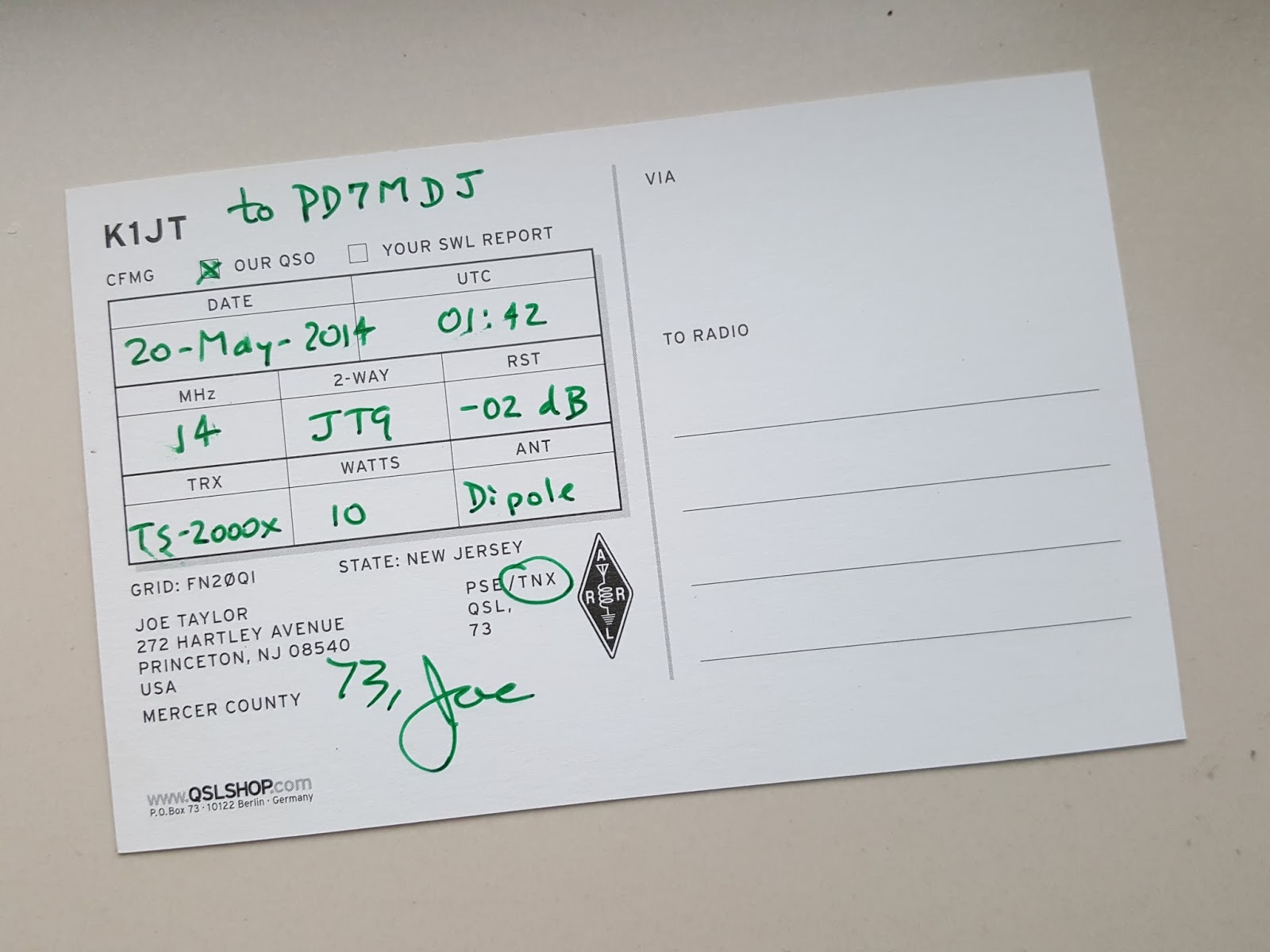
K1JT is the callsign of American astrophysicist Joseph H. Taylor Jr., better known to radio amateurs as Joe Taylor.
Joe Taylor developed the WSJT amateur radio computer program and is the inventor of digital weak-signal communication modes like JT65, JT9, and WSPR.
The JT65 mode has enabled radio amateurs, including myself, to make EME (moonbounce) contacts with relatively low power and modest equipment. I see the invention of JT65 as quite the revolution in EME communications.
Joe Taylor in 1993 won the Nobel Prize in Physics. Find facts and a biography here on Nobelprize.org.
One night when I was CQ'ing in JT9 on 20m HF, the inventor himself replied to my call! How cool is that!
On April 26, 2016 it was 30 years ago that the catastrophic nuclear disaster took place at the Chernobyl Nuclear Power Plant in Pripyat, Ukraine (then still part of the former Soviet Union, or USSR). A tragically failed systems test lead to a number of explosions and a huge nuclear leak in "Reactor 4". The accident has been described as the worst nuclear disaster the world has ever seen.
To commemorate the 30th anniversary of the tragic event, last April various amateur radio stations from Belarus, Russia, and Ukraine were active with special callsigns. Some Ukrainian radio amateurs even undertook expeditions to the abandoned towns of Pripyat and Chernobyl, and were active from the Chernobyl Exclusion Zone itself.
The Chernobyl Exclusion Zone, originally extending 30 km in all directions from the damaged reactor, was established by the USSR military soon after the disaster. The evacuated zone is largely uninhabited, except for some residents who refused to evacuate or have resettled. The zone today is controlled by the State Emergency Service of Ukraine, and one of its main purposes today is to restrict access to the hazardous areas around the former Chernobyl power plant. There are checkpoints at the zone's entrances and there are patrols inside the zone and along its perimeter. There's no way of just showing up and entering the area. Some scientists estimate it will take 20,000 years before people can safely live in the Exclusion Zone again. The zone however has been accessible to interested parties like scientists and journalists since its creation, and since 2011 also to interested tourists who wish to learn more about the tragedy, and to which guided Chernobyl tours are offered.
The Chernobyl Exclusion Zone (source).
Note that the Chernobyl Nuclear Power Plant is located in the town of
Pripyat, while the town with the name "Chernobyl" is lying roughly 20 km
to the southeast of it.
The Chernobyl Exclusion Zone, despite high radiation levels, has largely reverted to forest and, because of the lack of competition with humans for space and resources, wildlife (including moose, elk, deer, wild boar, lynx, and wolves) is thriving. Unintentionally, the area has become one of Europe's biggest wildlife reserves! The area (I have no information as to the exact WWFF perimeters, so I'm not sure if it's the entire area or just part of it) today even is included in the reference list of designated nature parks and protected nature areas of the Worldwide Flora & Fauna in Amateur Radio programme (WWFF). The WWFF reference number is URFF-0144 (Chernobyl Exclusion Zone Special Protected Area).
A family of moose in Chernobyl's Exclusion Zone (source)
On the website at http://1986.pp.ua/ru/ you can find more information about the Chernobyl-30 amateur radio commemorative programme. It's in Russian, but Google will help you a bit with the translation here.
The following stations were active from the Exclusion Zone:
EN5R on April 25th and 26th, 2016 was active from the ghost town of Pripyat very close to Reactor 4. The photos below show the EN5R team at their QTH in Pripyat on April 25th with the antennas used for their activity. In the background of the first photo you can see Reactor 4 on the left. In the middle you can see the New Safe Confinement structure, which, once completed, will be moved (in fact the New Safe Confinement is a huge rail vehicle) over Reactor 4 to cover it and limit the leaking of more radiation.
I worked EN5R on the 25th and 26th of April in CW and SSB on 40 and 20m (this was "Stage 2" of their expedition with their QTH close to Reactor 4 in Pripyat. I also worked them a couple of days earlier during the Stage 1 "Chernobyl is our Neighbour" part of their expedition, during which they were active from various villages in the Chernobyl area).
Listen here to a recording of my 20m SSB QSO with EN5R on 26.04.2016.
EM30U was active from the "Pripyat Hotel" in the town of Chernobyl in grid locator KO51cg (URDA KO-26 Kiyv region, Chernobyls'kyi district). I worked EM30U on 30m PSK63 and 20m CW. The resulting QSL card is shown below. For these QSOs I was also credited for URFF-0144 in the WWFF log database. Quite a rare reference to have in the log, I guess.
EM30U QSL card. At the time of writing, I'm still waiting for the cards to arrive from EN5R and EM7UT.
Listen here to a recording of my 20m CW QSO with EM30U. EM7UT also was active from the town of Chernobyl in grid locator KO51cg (URDA KO-26). I worked EM7UT in CW and SSB on 40m.
Listen here to a recording of my 40m SSB QSO with EM7UT.